1,337 operational onshore oil rigs, 240 offshore rigs, Maunsell Forts, Texas Towers, etc.
This page is dedicated to semi-fixed structures at sea.
Definition: These structure, whatever their purposes, are generally built with steel or any metal in shipyards, with buoyancy in mind, and with a self-propelled capability of some sort, and are generally towed to location. By contrast, naval fortifications are built on firm ground, and in a solid material of stone or concrete.
Leidos Mobile Depot Platform
World’s renown New York Gibbs & Cox architecture studio (now part of Eidos) presented recently (28 Jan 2025) a concept of “Oil Rig” for Logistical Hubs and faster VLS Reloading at SNA 2025. This structure, using the same construction methods as oil rigs, has the sole purpose of bringing an alternative to the usual mobile logistic train of the USN in case of war in the vast expanses of the Pacific. In a context where small islands and rocky outcrops in the South China sea are sanctuarized by China and transformed into fully fledged naval bases with logistic capabilities, offensive and defensive capabilities, and in the current hypothesis of a conflict with China over Taiwan in 2028, 2029, or sooner, this private venture proposal is now considered by the USN. Leidos Gibbs and Cox indeed proposes to procure a more resilient station than a logistic vessel to traditional naval threats, with the same capacity in order to resupply, far from home and quickly, containerized missiles to the USN’s VLS (Vertical Launch Systems) notably used by the current Arleigh Burke class and future Constellation class Frigates.
This “ammunition depot”, called the Mobile Depot Platform as promoted, could indeed resupply four ships at once, instead of a traditional supply ship which could only reliably resupply a single ship sideways and underway. This quick reloading capabilities comes in handy with the prospect of a return of high intensity naval warfare, where the current tactic is to use coordinated saturation fire.
Without entering details of that concept, it is an interesting solution to a current problem that was solved in WW2 by the constitution of a very large logistic fleet in support of TF 38/58, the fast fleet carrier task force that won the war in the Pacific. Current tasks forces are not less dependent of logistics, which is why the US reinforce on the geopolitical sphere its linked with regional powers, Japan, South Korea, Singapore, the Philippines, all potentially part of this logistical hub. But outside Guam and Hawaii, far from the South China Sea, the USN will need depots, ideally that can be redeply at the most useful rear-echelon site, like Majuro atoll was back in 1944. See also on naval news
Oil Platforms
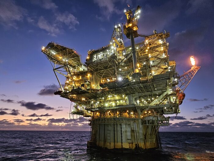
They literrally propelled our modern world, they are the tallest man-made structures ever transported, employees are among the best paid “manual workers” on the planet, and they are planted remotelly at sea, seeing some of the fiercest environments on the planet. All this and more, created almost a lore around these giants of the seas. Wether they are called Oil platforms or Oil rigs, the fascination they exert found its way in many movies until recently, and it’s certainly far from over. These are our earthly “space stations”, combining spicy elements for a thrilling, bone-chilling story often bordering on supernatural.
So i wanted to cover these topic and for this, decided to split this long article in two main parts, to bring these some justice. First, a study of the fundamentals of an oil rig, their history, landmarks, technical features, organization and operation as well as ancillaries. And in the second part, a catalogue of past and current oil rigs, that i wish to complete over time, based on existing OSINT.
The second chapter of this page is devoted to “naval forts”, but not the ones already covered by the page on naval fortfications, according to the definition above. The best known are the WW2 Maunsell Forts and Cold War Texas Forts, but if satellites retook part of their jobs, there are still nw applications which could make thel still relevant.
Hope this will correct that “blank spot” which is apparently far from warships but which in reality saw (and still sees) concrete military applications, projects and realizations over the years, as well as being a real strategic asset in case of war, to be protected by naval power.
Fundamentals: An introduction of Oil Rigs
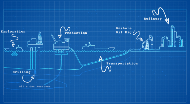
Let’s start with a definition: An oil platform (also called alternatively oil rig, offshore platform, oil production platform) is a large structure containing all facilities needed to extract and process petroleum and natural gas. The real purpose is to go tapping deep into rock formations beneath the seabed, something that was held as sci-fi fantasy for many years. But as the so controversial (and powerful) oil industry, more than 150 years old now is seeing its land reserves pumped dry, new ways of extractions were seeked in the 1980s. Each time, the industry needs to ramp up its technological game, to drill always deeper and further at sea. This goes with a lot of challenges of its own, making these facilities among the costiest and most complex of any industry anywhere.
The origins of oil exploitation
It’s a common misonception to think the use of crude oil goes back only to the XIXth century. “Naphta” was known to ancient antiquity, and to be more precise, thousands of years before the modern era the very first record of a permanent drill in China was recorded in 347 AD. It was used for its burning properties, but more commonly as a better substitute to Tar, for waterproofing wooden hulls. Hence, it’s ancient use was already linked to the sea.
However the modern history of its industry goes back indeed to 1847, through a scientific discovery made by Scottish chemist James Young. He observed the residues of coal mine seepage, and distilled it into a light thin oil even better suitede for lamps there, or a thicker one used for lubrication.
After this he further experimented with coal distillation before finding the perfect compound, the earliest form of modern industrial petroleum, which he patented as “paraffin wax” in 1850, and later partnered with geologist Edward William Binney to find more sources, creating the first commercial oil refinery.
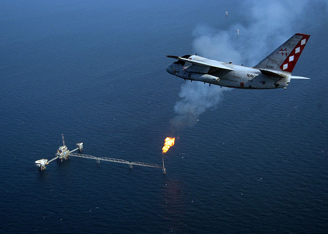
In 1846, also Canadian geologist Abraham Pineo Gesner compared refinining of coal, oil shale and bitumen, finding a compound burning more cleanly than other oils, calling it “kerosene” creating a Gaslight Company in 1850, lighting Halifax, before going into the US Market at large.
The coal industry, all-powerful at the time, also searched for more derivatives and started to follow the model created by Young and Gesner. In 1952 Polish engineer Ignacy Łukasiewicz improved the process and turned both kerosene and petroleum in Bóbrka two years later. But it’s in 1857 that the first oil well drill was created, in La Brea, Trinidad, reaching 280ft, by the US-based Merrimac Co. Later Edwin Drake in Titusville (Pennsylvania) created the first oil field, in 1859, starting the first ‘oil rush’.
Until the early 19th century major oil companies were created, now famously established “big names” of the industry.
John D. Rockefeller created the Standard Oil Company in 1865, distributing under the brand Standard Oil in Ohio. ExxonMobil was its most prominent successors after it was dissolved in 1911.
It’s in Russia, that the first oil tankers operated, by British trader Marcus Samuel, with the SS Murex, first oil tanker going through the Suez Canal, flagship of Shell Transport and Trading, later Royal Dutch Shell. In Masjed Soleyman, Iran, William Knox D’Arcy discovered an oil field and created the Anglo-Persian Oil Company in 1907, by 1954 British Petroleum (BP). At last by the late 20th century, Iran, Iraq, Kuwait, Venezuela and Saudi Arabia created OPEC in 1960 to answer the weight and influence of the ‘Seven Sisters’ (notably the newly created ExxonMobil) and rose to 15 member today, accounting for 44% of global oil production, and still 81.5% of the world’s oil reserves. Outside this, oil fields are now quite hard to find, leaving new methods of exploitation, costly and complex. One of these was offshore drilling.
How offshore platforms operates
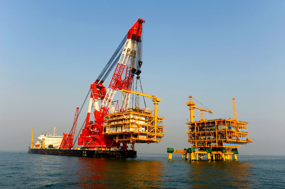
Many oil platforms are basically industrially standard replicas of land based drilling units, but more compact, with platforms supporting housing facilities to accommodate the workers, and helipad for rapid tranfer or personal and supplies to the shore. Indeed, placed in high seas, the use of boats is more difficult due to the sea conditions most of the time. Oil platforms however are not placed anywhere. They operates only on the continental shelf, former submerged dry lands with certified biologic deposits of prehistoric times. Its not uncommon to fing platforms also in lakes, inshore waters and inland seas, linked always to these spotted ancient mineral deposits.
A platform could be directly fixed to the ocean floor when possible, creating an artificial island. In that case, it’s safer to resit all sorts of natural hazards, but this restrict their use on limited water dephts. Or depends on very large structures, usually made of cheaper reinforced concrete instead of all-steel. Some among these are the tallest structures ever built at sea.
A platform also can float. In that case, it could rest on pontoons, anchored if possible on the bottom, or rely on a complex system of propeller pods stabilized with GPS. More costly, theey are more susceptible of natural hazards, but can be towed to any place relatively easily. Some of the largest platforms even integrated storage facilities for the processed oil, notably remote subsea wells connected to the platform by flow lines and umbilical connections. They could also have multiple manifold centres connected to various wells in a working network.
Accidents and environmental threat
Today, these Offshore drilling anyway are criticized by ecologists as an away present environmental challenge. There has been a serie of famous accidents involving the complete loss of some stations, most emerging from human errors with considerable consequences, such as:
C.P. Baker Drilling Barge disaster, Gulf of Mexico, 1964
Bohai 2 oil rig disaster, Gulf of Bohai, China, 1979
Alexander L Kielland, Norwegian North Sea, 1980.
Ocean Ranger oil rig disaster, Canadian Atlantic Ocean, 1982.
Glomar Java Sea drillship disaster, South China Sea, 1983.
Enchova Central Platform disaster, Brazilian Atlantic Ocean, 1984
Piper Alpha, UK North Sea, 1988.
Seacrest Drillship disaster, South China Sea, 1989.
Mumbai High North disaster, Arabian Sea, 2005
Usumacinta Jack-up disaster, Mexican Gulf of Mexico, 2007
Deepwater Horizon disaster, Gulf of Mexico, 2010 (the best known, with movies and documentaries to boot)
In some case, it’s a collision, in other case a human action overruling safeties and causing a fire, or a simple open porthole combined in an electronic control room, by a rogue wave… src
Oil Platforms at war
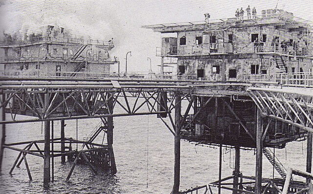
Operation Praying Mantis: US Marines on top of the Iranian oil platform of Sassan. April 18 1988. This attack by the United States on Iranian naval targets in the Persian Gulf was in retaliation for the mining of a U.S. warship four days earlier. The Iran-Iraq war saw both sides trying to attack their respective oil-drilling assets. As the war started on 22 September 1980, Saddam hoped for a quick victory. The retaliation was the successful Operation Morvarid (“Pearl”), launched to both take on Iraqi radars off but also vital oil infrastructure as well as giving the Iraqi Navy a bloody nose in the process. The attack targeted Iraq’s Mina al-Bakr (al-Basrah Oil Terminal) and Khor al-Omayah in the al-Faw peninsula.
In November, Iraqi artillery managed to be close enough to destroy the Iranian oil terminal Abadan. This was the start of a long list. Both sides continued to built infrastructures anyway to keep their vital oil industries working. There was also the “tanker war”, just as effective. Performed by both sies, military attacks against merchant vessels in the Persian Gulf and Strait of Hormuz from 1981 to 1988 topped at 283 attacks for Iraq and 168 for Iran. Given their strong resilience, mosty tankers survived these attacks, only 5 sunk, more ran aground and the remainder made for home, more or less badly damaged. The UN despatched vessels to escort them as it was vital to protect these both to sustain international industries and economies, and out of environmental concerns. UN-backed Operation Earnest Will (24 July 1987 – 26 September 1988) managed to stop or make inneffective these attacks.
Types of facilities
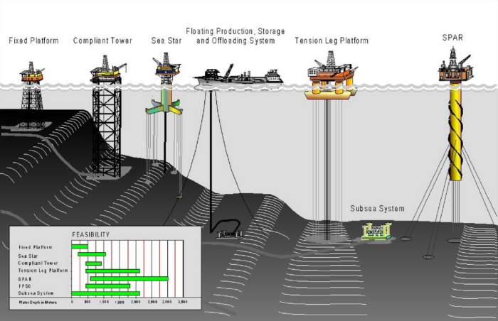
Deepwater Drilling Systems
Bottom-founded drilling rigs, jackup barges and swamp barges
Combined drilling and production facilities (bottom-founded or floating platforms).
Deepwater mobile offshore drilling units (MODU) (with semi-submersibles and drillships).
The latter are capable or drilling down to 3,000 metres (9,800 ft) and are anchored to the seabed in shallower waters, but beyong 1,500 metres (4,900 ft)) they used semisubmersibles or drillships maintained by dynamic positioning and thusters. src
A catalogue of Oil Platforms
Like for shipbuilding, the oil industry likes to create “fields” of identical or standardized platforms (let’s call them “classes”) to keep budgets down and ensure well-tested solutions over time, with gradual improvements and up-scaling. It’s a proven, cost-effective process similar to many industries today (Work in progress). Its the preferred way over than taking a great technological leap forward piling up innovations, which are too often synonymous with investors’s risks, uncertainty, teething problems, redesigns, and in the end massive cost overruns plus a delayed service entry. The financial weight of this particular industry means investors are just too cautious to go this way. There are exception still, but not many.
In this chapter i’ll try to document the oil platforms over time, with their construction, entry into service and discarding dates, possibly major events during their exploitation life, just like ship’s career. It should be added that these platforms are mobile, and when an area is pumped dry, it happened these are just moved away if not too old.
 Californian Drilling Piers (1859-1932)
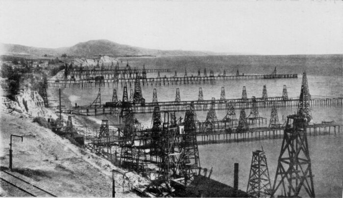
Summerfield wells, Santa Barbara, (NOAA Coll.) – The first pier-based oil onshore rigs.
Offshore drilling started in 1897, 38 years after Col. Edwin Drake drilled the first well in 1859 with the assistance of H.L. Williams. A well was drilled off a wooden pier in the Santa Barbara Channel, California, next to an existing field. Five years later, 150 of these wells were implanted in the area and by 1921, steel piers were built at Rincon and Elwood also in California, while in 1932 a fully steel-pier island (60 × 90 ft with, 25 ft over the surface) was created just ½ mile offshore by Indian Petroleum Corp, called the first onshore-type rig. It was the very first steel-jacketed autonomous drilling platform at sea.
 Gd Lakes Drilling Platforms (1891)
Around 1891, the first submerged oil wells were drilled from platforms built on piles in the fresh waters of the Grand Lake St. Marys in Ohio. The wells were developed by small local companies such as Bryson, Riley Oil, German-American and Banker’s Oil.
 Louisiana On-water drilling barge platform (1934)
First “on-water drilling” platform: It was born in the swamps of Louisiana by the early 1930s, using shallow-draft rectangular barges modified with a narrow aft slot for the well conductor. Tugs could move the barges to various locations and later they were more permentenly “posted” on a lattice steel structure to reach deeper depths, the barge being completely submerged in the bay, using pilings.
Specs unknown.
 Mexico Gulf Kerr McGee TAD unit (1947)
On 9 September, 1947 using a tender assist drilling (TAD) unit (Kerr-McGee) Gulf of Mexico (GOM). A former WW2 surplus 260 × 48-ft barge was completely modified with a drilling equipment set (DES), comprising a drawworks, derrick, and hoisting equipment, all based on a wooden pile platform. Nor more data available, nor specs.
 Breton Rig 20 (1949)
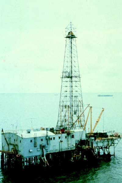
The Breton Rig 20, designed by John T. Hayward working for Barnsdall Refining Co. at the time) was a “posted” submersible barge patented in 1949. It exploited oil fields in open waters of Louisiana. It contained all the drilling equipment on a single barge towed as a complete unit. It was converted inland drilling barge with two stability pontoons hydraulically jacked up and down. The Breton Rig 20 (later Transworld Rig 40) got rid of the need of a wooden platform. It was still in shallow water, no more than 20 ft (hence te name) but became de facto the very first mobile offshore drilling unit (MODU). No data avilable.
 Neft Daslari (1951)
Neft Daslari was not a simple platform, but an entire functioning town large enough for 5,000 personal, constructed in the Caspian Sea, 55 km from the coast of Azerbaijan. Construction started in 1949, oil production commenced by 1951. The offshore town grew to include hotels, a bakery and a power station over 7 ha, made up of separate ‘islands’ connected 200 km of trestle bridges, all posted on metal stilts. It had been reclaimed since by the sea but the rigs are still in production, making it today the world’s oldest offshore oil rig in exploitation.
⚙ specifications |
|
| Displacement | Unknown, ca +50,000 tonnes |
| Dimensions | 7 ha (0.3 Sq. Miles) |
| Propulsion | None (fixed) |
| Equipments | 30+ drilling rigs, facilities |
| Crew | 5,000 (1959) |
 “Mr. Charlie” (1954)
The first true offshore MODU: “Mr. Charlie” was designed and constructed from scratch by Ocean Drilling and Exploration Co. (ODECO). It was created by its own inventor and ODECO president “Doc” Alden J. Laborde. It was a purpose-built submersible barge floating on its lower hull, using stern down flooding until it rested on the bottom. “Mr. Charlie” was first posted in June 1954, greeted by an article of Life magazine which really spread the world the idea of possible offshore drilling operations. Mr. Charlie could operate to double the Breton Rig, at 40-ft water depth. But it really triggered quantities of MODUs in the Gulf of Mexico (GOM), later exploited by Murphy Oil, and then Shell Oil for long term exploitation.
It was retired in late 1986, and is now a museum and training rig in Morgan City in Louisiana.
 Troll A Platform (1994)
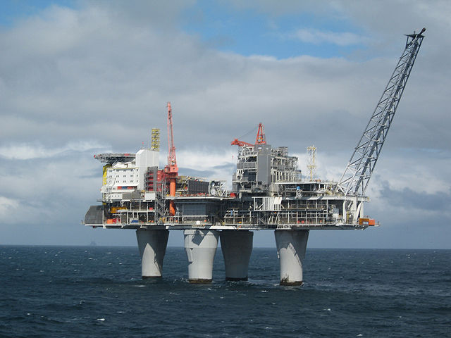
This Condeep gravity-based structure offshore natural gas platform now located in the Troll gas field off the west coast of Norway was built in 1994-95 from reinforced concrete and still was the tallest structure ever moved to another position relative to the surface of the Earth (as of 2014), and among the largest and most complex engineering projects in history. Made of three legs with an overall height of 472 metres (1,549 ft) for 683,600 tons (1.2 million tons with ballast). Inside the dry legs, could be hosted any event, like a concert held under 303 metres (994 ft) below sea level.
⚙ specifications |
|
| Displacement | 683,600 tons light |
| Dimensions | 472 metres (1,549 ft) Tall |
| Propulsion | None, towed and anchored in place wirh 6x 40 metres (130 ft) tall vacuum-anchors |
| Equipments | Helipad, standard gas rig. |
| Crew | c40 |
 Gullfaks A/B/C (1986-90)
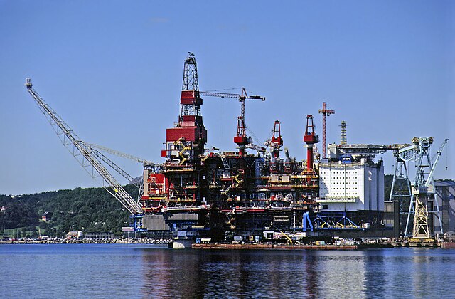
Norway in the mid-1980s worked on three giant oil platforms in order to exploit the 1978 discovered Gullfaks oil field. They kept the guiness record for the largest offshore platforms, taller than the Eiffel tower and in their time, Gullfaks C held the record of the heaviest object ever moved to another position, relative to the surface of the Earth with a total displacement between 1.4 and 1.5 million tons. Gullfaks C sits 217 metres (712 ft) below the waterline for a total height of 380 metres (1,250 ft), more than A (135m) and B (142m). The three giants reached peak production in 2001 (180,000 barrels per day). The still remaining recoverable reserve in 2004 was estimated 234 million barrels.
⚙ specifications Gullfaks C Concrete gravity platform |
|
| Displacement | 370,000t substructure, 49,000t topside |
| Dimensions | 380 metres (1,250 ft) |
| Propulsion | None, towed into place |
| Equipments | Helipad, standard, 4 legs, 24 cells. |
| Crew | c300 |
 Baldplate Platform
offshore compliant tower oil platform sitting near the coast of Louisiana (Hess Corp.), first freestanding compliant tower following the Lena platform, a guyed compliant tower and second tallest structure built in water after Petronius. Baldpate is designed to move up to 10 feet laterally during storms. The complaint tower section jacket section was fabricated by Aker Gulf Marine and is 28,900 tons alone. It is sitting steel piles under a depth of 430 feet. The upper 402 m (1320 ft) tall tower section weights 20,200 tons.
⚙ specifications |
|
| Displacement | 38,700t |
| Dimensions | 579.7 metres (1,902 ft) |
| Propulsion | None, towed into place |
| Equipments | Helipad, standard |
| Crew | c200 |
 Petronius (1998)
A compliant piled tower design 640 metres (2,100 ft) high, tallest free-standing structure worldwide before the Burj Khalifa in 2010. It is partially supported by buoyancy. Its multi-deck topsides are 64 metres (210 ft) by 43 metres (141 ft) by 18.3 metres (60 ft) high with 21 well slots. Total weight is 43,000 tons with the topside representing 7,500 tons for a capacity of 9,600 m3 (60,000 barrels) of oil and 3,000,000 m3 (100 million cubic feet) of natural gas daily.
⚙ specifications |
|
| Displacement | 11,800t |
| Dimensions | 640 metres (2,100 ft) tall |
| Propulsion | Towed into place, buoyant |
| Equipments | Helpad, standard |
| Crew | c200 |
Offshore Forts
There are debates over the term of “naval fort”, some still arguing that a solid-built fort on a rocky outcrop out at sea should be considered as such. However we need here to go the definition of “sea fort” which is perhaps not much enlightening, but is generally accepted as this later definition. We should thus consider rather than “naval forts”, the term of “Offshore Fort” should be preferrable to avoid confusion.
Churchill’s mid-Atlantic naval bases
Outside Project Habbakuk, a giant concrete-ice mixed aircraft carrier usable as mid-atlantic base, the Allies contemplated solution to solve their mid-atlantic gap issues against U-Boats, leading to proposals of conctrete or steel built platforms anchored if possible on the plateau south of Groenland. It was indeed impossible to anchor these down to the abyssal plain dominating the Atlantic and the ridge was known already in 1925 but only was 2277 m (7470′) tall at Jan Mayen for an average of 6000-7000 m depth, 7,758 m (25,453 ft), for the Romanche Trench.
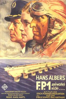 Floating bases were not a new concept, amidst the WW1 naval operations in the Atlantic already. There was even a German 1932 supeproduction movie made, FP1, by UFA-Filmverleih. Its plot concerned a permanent air station in the middle of the Atlantic Ocean. The movie does not go into much detail on how it was supposed to be moved and left in place though. At the time it was presented as peacefule endeavour, to allow intercontinental flights to refuel and repair any damage mid-way across the pond.
Project Habbakuk
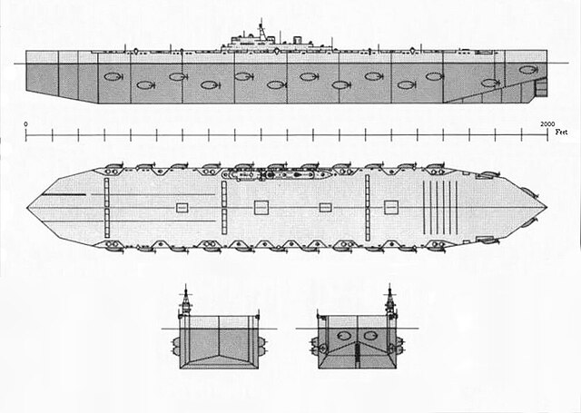
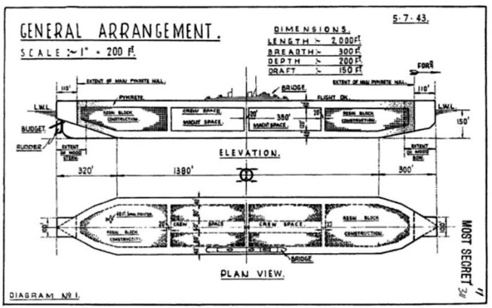
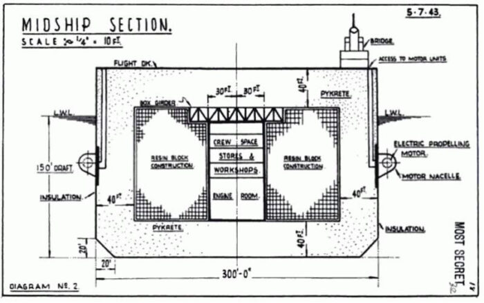
Project Habbakuk, the “pykrete” or “ice-wood pulp carrier” was one of the most outlandish military engineering experiments of the War. Championed by Mountbatten and endorsed by Churchill, the project was essentially a “moving island” housing and operating land-based heavy bombers to help close the Mid-Atlantic gap, cheaply built out of nonstrategic materials and reputed unsinkable by its inventor, Geoffrey Pyke. Mountbatten even fired at point blank with his service pistol on a sample of that mixture for good measure at the Quebec Conference in 1943. But the bullet buzzed around in a room filled with VIPs and it was a miracle that nobody war hurt. Unfortunately the same was done at the Combined Operations Headquarters (COHQ) by a naval officer, Lt. Cdr Douglas Adshead-Grant, did the same, and injured CiC Sir Alan Brooke in the process.
Obviously the “carrier” was to stay in the north atlantic for water temperatures. However nothing was said about the salinity effect on ice. But the refrigeration plant needed to keep the mix freezed used so much steel it was unworkable. The project was still pushed forward by the National Research Council of Canada, creating a reduced prototype in 1944 on Patricia Lake near Jasper, Alberta. It confirmed the manufacturing cost would be the same as a fleet of carriers. In three summers, the prototype completely melt down. In between the situation changed as permission was received from Portugal to use airfields in the Azores, new long-range fuel tanks were given to UK based Fleet Air Arm long range aircraft for longer patrols and many more escort carriers were built by the US at a far lower price, making the Habbakkuk (the name came from the bible) redundant. More small scale experiments resurfaced in 2009-2010 showing the idea was unfeasable. In fact concrete ships made more sense.
US Projects
However the idea resurfaced with the US. Actually the the longest floating structure ever built by the Navy came into existence in October 1943 and even conducted flight operations in November. Under “Project Sock” this was a 1,810-foot long floating airfield. In general other ideas for “floating islands” were considered, such as welding two Liberty Ships or two tank landing craft together as a catamaran (or more hulls) fitting a large platform above (Project TENTACLE).
In Washington D.C. U.S. Navy engineers evaluated the viability of Habakkuk and the U.S. Navy decided also against Habakkuk based on the materuals needed for the refrigeration plant to freeze the pykrete and similarly concluded that the increasing range of land-based aircraft and new escort carriers promised by Kaiser Yards (such as the Casablanca class) made the project unsustainable.
https://www.usni.org/magazines/naval-history-magazine/2024/february/pieces-past
https://thecretefleet.com/f/guy-maunsell%E2%80%99s-admiralty-floating-docks?blogcategory=Floating+Dry+Docks
https://www.secretprojects.co.uk/threads/project-tentacle.1719/
WW2 Concrete ships
The problem of strategic materials in war production pushed some to explore new materials. De Havilland famously delivered in 1940 it’s “wooden wonder”, the Mosquito, but this was the exception that confirmed the rule. Miles also proposed in 1940 a small wooden low budget fighter. In terms of ships, UK made all its light vessels for the Coastal Forces, except the large SGBs (Steam Gun Boat) in wood. All British Motor torpedo boat and Type Two 63 ft HSL were made in wood. The US also produced a large number of wooden vessels (“splinter navy”), from wooden subchasers of WWI still operational, with its SC-1-class submarine chaser, and SC-497-class submarine chaser. Louisana’s PT boats were also all made of wood mixes with composites and plastic, as were its numerous 104-foot, 85-foot, 63-foot and 42-foot crash boats manned by USAAF personal to rescue pilots.
Also made in wood by the allies were numerous minesweepers (because of magnetic mines) which often doubled as ASW escorts (Accentor-class, Raven-class, and Auxiliary motor minesweepers), the APc-1-class transport, many netlayers, Type V tuboats, 83-foot patrol boat, British Yard patorl boats, US 36-foot Cabin Picket Boats and others, fireboats, wood barges, motors launches, command boats, and most landing crafts including the famous mass-produced LVCP by Higgins.
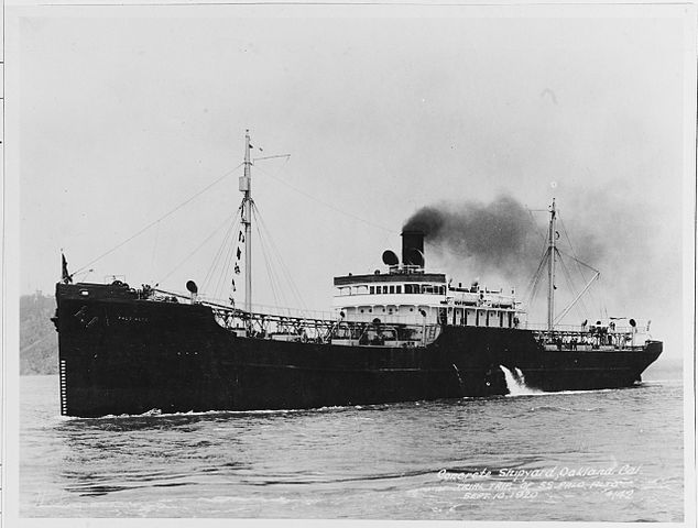
SS Palo Alto, a 1919 US concrete oil tanker.
However contrete was less obvious given its comparative bulk and weight. Its only saving grace was it was cheaper, easier to manufacture, but only provided enough buoyancy is its shape was made in a certain way. The material was just obviously unsuitable, just as the idea of a “rock ship”. Still, done the right way, it could prove useful. Many WW2 ships had already concrete poured in on their hull bottom as ballasts to combat topweight. Examples of WWI concrete ships to replace merchant losses to U-Boats was already done, with the SS Faith (launched March 18, 1918) to carry bulk cargo for trade until 1921, as ferrocement ship. It worked, and in April 12, president Wilson approved the Emergency Fleet Corporation program which included 12 ferroement ships, completed, but too late for WWI and resold to private companies and used foir some time.
https://en.wikipedia.org/wiki/Concrete_ship
https://en.wikipedia.org/wiki/Type_B_ship
Maunsell Forts
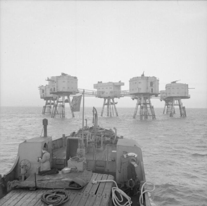
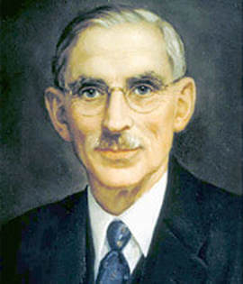 Probably the best known of these “sea forts”, the concept was invented by Guy Maunsell, a British civil engineer responsible for the design, which also signed the famous Mullberries of post-D-Day. He was born in British India, and when travelling in Europe he became assistant to Swiss engineer Adrien Palaz, learning the latest technique in reinforced concrete. He later worked at Rosyth Dockyard and in WWI was at the head of two state TNT factories. He took part in the war, enlisted with the Royal Engineers, spending a year on the Western Front in 1917-18. In 1918 he entered John Ver Mehr’s yard in Shoreham, constructing concrete tugs and barges, the “Shoreham Creteships”.
He also worked to create concrete and steel towers for the Admiralty M-N Scheme, the late war project to close the strait of Dover to U-Boats once and for all with twelve massive towers linked by anti-submarine booms and nets.
In WW2 he worked on the famous Maunsell forts and Mullberies among others and postwar created his own company, still in the same construction business but inventing and patenting pre-stressed concrete. He passed out in 1961 at Tunbridge Wells, Kent. Photo: Credit hildenboroughhistorysociety.weebly.com.
In WW2 the expertise of Maunsell in concrete could be applied to numerous projects. With the U-Boat war, the “Dover line” was briefly resurfaced and dropped as the contect changed. Indeed now the greatest use for possible offshore structures was to give early warning to the RAF command in the battle of Britain. Installed in the Thames and Mersey estuaries, they could warn off in advance and fire at, Lufwaffe formations, and prevent attempts to lay mines by aircraft in these vital, busy trade lanes for britain. The forts he designed were located at Rough Sands (HM Fort Roughs) (U1), Sunk Head (U2), Tongue Sands (U3) and Knock John (U4).
His structures, installed from February 1942, were of two types, the Navy and Army Forts. They diverged in structure and design.
Navy Forts
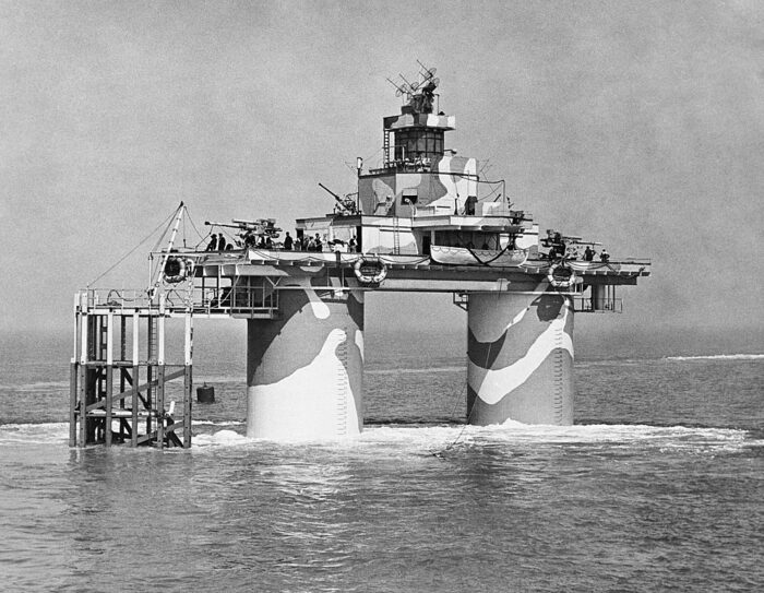
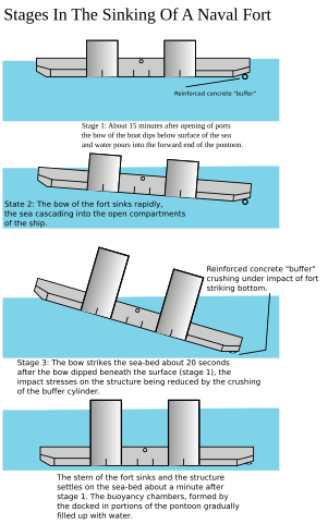 The Navy forts were made of concrete with two tank like pillars on a barge-like “foot” which anchored it at the bottom. The pillars then suported a large utility platform. Thies artificial naval installations were inspired by early “fixed” offshore oil platforms. The “foot” was a rectangular 168-by-88-foot (51 by 27 m) reinforced concrete pontoon base. Above it was a support superstructure with the pillars being 60-foot (18 m) tall, 24-foot (7.3 m) in diameter and hollow, also in reinforced concrete.
The walls roughly 3.5 inches (9 cm) thick. Total weight of the structure was 4,500 tons. The twin concrete supporting towers were not just completely hollow but subdivided into seven floors, the underwater ones usually housing generators. Four upper ones were for crew quarters. The remainder provided also dining, operational, and storage areas. There were also fresh water tanks and antiaircraft munitions. A steel framework on one of these supported a landing jetty (the “dolphin”) and crane to hoist supplies aboard.
Above the towers was located a steel platform deck for structures to be installed, such as a gun deck, upper deck, central tower/command unit, and radar. In general, the two outer quarters of the platforms were used to installed QF 3.7 inch anti-aircraft guns ad often two Bofors 40 mm anti-aircraft guns. In the middle was the central tower radar installation, atop a central living area with a galley, medical, and officers quarters.
The concrete equalled a military grade bunker. Over time and especially postwar these forts were scrapped to avoid beign a hazard to navigation but one survived. Many species of fish developed around these towers which created their own environment of marine life. But they also became a landmark reference in the area. These concrete structures were built in dry dock and assembled as complete units, fitted out with a first visit by crews for initial training, before they were towed at sea and anchored in place. These forts answered Admiralty requirements. Although they were mostly intended at combating the Luftwaffe, the guns could depress enough to fire at a surface U-Boat and once, the Thames estuary Navy fort destroyed a German E-Boat. That was the only “kill” of these forts in wartime outside aircraft. 
As of today, only Rough Sands Fort survives in its integrality.
Rough Sands Fort (U1)
U1 was erected in February 1942 to protect the ports of Felixstowe, Harwich and the town of Ipswich from aerial and sea attack, placed on a sandbank c11 km (6 nm) of the coast. She was commissioned into the Royal Navy as “H.M. Fort Roughs” on 8 February with a crew of c100, with rotations more or less equivalent to ships, albeit the fort was anchored on the 11th. Postwar it was left in place to signal the presence of the sandbank to shipping, albeit completely dilapidated over time.
In 1966 Paddy Roy Bates (Radio Essex) and Ronan O’Rahilly (Radio Caroline) made a liuve radio broadcast from the fort, without authorization, and the latter was eventually stormed by British Royal Marines. Before that, Bates proclaimed there the “Principality of Sealand” founded 2 September 1967.
Sunk Head Fort (U2) was 18km from the coast of Essex, anchored and operational from 1st June 1942. Postwar it was also illegally occupied by a broadcaster as being in international waters, and stormed on 18 August 1967 by the 24th Field Squadron of Royal Engineers. It was filled with 3,200 pounds of explosives and bown, leaving just 20ft of the underwater structure standing.

From Pinterest, Thames Forts
Tongue Sands Fort (U3) was commissioned 10.2 km from Margate on 27 June 1942. This one saw action in the night of 22/23 January 1945, when fifteen German E-boats were spotted on radar, five closing by. General quarters were ordered and S.119 or S.199 from IJmuiden were suddenly caught by a light projector just 4 miles away from the fort, immediately came under heavy fire by the two 3.7-inch guns. When manoeuvering to dodge shells, one E-Boat rammed the other, and it was so badly damaged as being scuttled on site and the crew evacuated. This thus a “kill” by the fort, albeit an indirect one. Tongue Fort was decommissioned on 14 Feb. 1945 and left in minimal care maintenance until 1949 and abandoned, noted to be unstable. It started to fall apart already in 1947, and eventually collapsed in the storms on 21/22 February 1996.
Knock John Fort (U4) was grounded 16.1 kilometres (9 nmi) from the coast off Essex on 1 August 1942, decommissioned on 14 June 1945, evacuated but maintained until May 1956 and then abandoned. The justification of maintaining these forts postwar was for a possible reactivation as radar pickets in case of war with USSR. In 2009 the strcture was surveyed ad degrading due to underscouring. It is the second of such structures still standing.
Army Forts
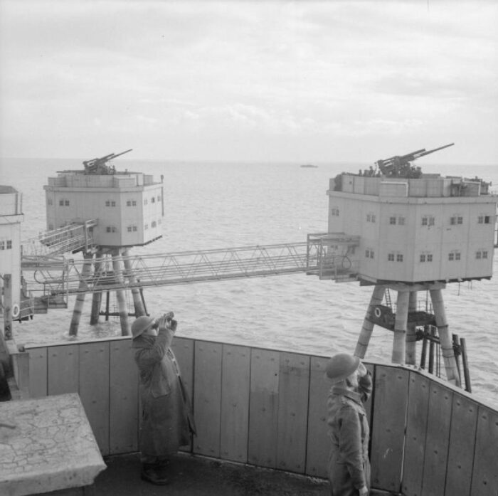
Maunsell army forts were specifically designed for anti-aircraft defence, managed by the army’s AA specialized units out at sea. These were larger installations made of seven interconnected steel platforms, almost a “suspended town” off shore. It comprised generally four towers in a semicircle, ahead, and connected to the control centre like the spokes of a wheel. The remaining two were aft of this structure. Bit other forst had different arrangements. Each tower was made in steel in drydock, with two stages and a roof supporting outer extensions platforms for AA guns, generally the same caliber as Sea Forts (3.7 inches guns (94 km)).
These were Britain’s primary heavy anti-aircraft gun during World War II, roughly the equivalent of the German Flak 8.8 cm and American 90 mm. In addition to one QF 3.7-inch gun each tower had a control centre with a Bofors 40 mm gun on top. One tower had a searchlight while the control tower had a radar. The typical composition was comprised one Bofors tower, one control tower, four gun towers and a searchlight tower.
They were composed of four legs anchored in a concrete foote heavy enough to support the structure, carried by a barge and floated out and grounded in water no more than 30m (100ft) deep. Construction of the steel towers was relatively quick, at Bromborough Dock for the Mersey forts, with the Thames forts at Gravesend.
Three Army forts were placed in Liverpool Bay, Queens, Formby and Burbo AA Towers. Three were installed in the Thames estuary, Nore (U5), Red Sands (U6) and Shivering Sands (U7). Proposals tfor such forts to be installed in the Humber, Portsmouth & Rosyth, Belfast & Londonderry were cancelled in 1944. The Thames estuary forts which entered service in early 1943 shot down 22 aircraft and 30 flying bombs. They were decommissioned in the late 1950s. Fort Nore is the best preserved today.
Texas Forts
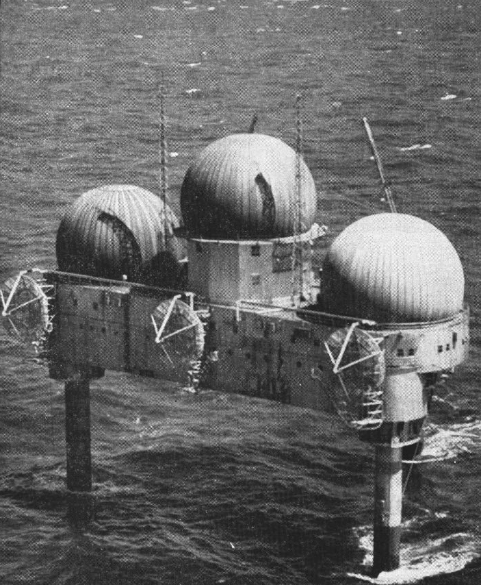
The “Texas Towers” were a type of off-shore radar facility, three were installed (out of five planned) off the eastern seaboard and used for surveillance by the USAF during the Cold War. They were modeled on the offshore oil drilling platforms typical of the Texas coast, and were in operation 1958-1963. However after the collapse of one in 1961, the remaining towers were closed. Indeed technology caught up to detect incoming threats and the towers were now considfered too dangerous for their crews to operate.
Their origin lays into the re-formation of the Air Defense Command in 1951 with the creation of a large surveillance radar network. It was believed that the shore-based radars on the east coast would provided insufficient warning time so a 1952 report from the MIT preconised to build off-shore platforms on high points in the Atlantic, using offshore oil drilling technique for their construction and implementation. The idea was to extend this detection by several hundred miles offshore for an additional 30 minutes warning for to prepare and/or for interception. Funding was approved in January 1954.
Each “tower” was made of a triangular platform, 200 feet (61 m) per side and standing on three caisson legs. Constructed on land they were towed on site, and jacked up to clear the sea surface then anchored under 67 feet (20 m). Then all equipments were installed on location using barge cranes. The platform was ttall enogh for two utility floors, housing living areas whereas the legs were used as fuel oil tanks for diesel generators powering the whole station. A third leg held an intake for the desalination unit, providing fresh water to the crew. The platform roof also had an helicopter landing area. There was for service a rotary gantry suspended from the platform on its underside. A barge would come underneath to have its palletized content jacked up in regular supply runs.
Each platform purpose was long range detection and for this, an AN/FPS-3 (later AN/FPS-20) search radar was installed, completed by two AN/FPS-6 height finder radars, all housed in spherical neoprene radomes, 55 feet (17 m) in diameter. It was at first theorized these towers could be linked to shore by submarine cable but it was deemed too costly. Instead they had a classic UHF-VHF radio set, and there was AN/FRC-56 tropospheric scatter microwave link installed with three parabolic antennas at the edge of the platform. The platform could comunicate at all times with ships and aircraft and act as command station if needed.
The command center and logistical support was at Otis Air Force Base (4604th Support Squadron). Personal was from the USAF. The station TT-5 was planned but never installed as well as TT-1. TT-4, TT-3 and TT-2. 1 and 5 were The most northerly, scrapped due to budgetary constraints. Otis provided also supply and personal rotation via H-21B helicopters, later Sikorsky SH-3 helicopters from 1962. The USNS New Bedford provided heavier sea supply via the platform “donut”, an inflated rubber ring with railing lowered from the platform to the waiting ship’s deck. The ship needed to maintain position and meteorology could hamper its mission.
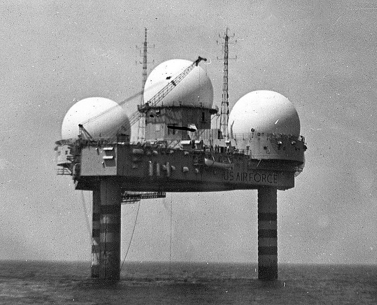
As said above, TT-4 installed off Long Beach Island, New Jersey was operated by the 646th Radar Squadron, Highlands Air Force Station. It collapsed in 1961. After this, the two others were decomissioned in 1963. TT-2 was the first operational in 1958, the two others in 1959. They were noisy, prone to vibration from the equipment in addition to the supports being flexible, shaking and swaying with wind and waves. This made life on board painful for the crew (c100). TT-4 had its installatrion botched up apparently. Nicknamed “old shaky” it made its crew’s life miserable. September 12, 1960 saw Hurricane Donna ravaging the station which lost its helideck, all installation wrecked and communication lost. Later it was decided of limited repairs and reduce staffing to a skeleton crew. As a storm was gerthering in January 1961, efforts were made to rescue the crew, but due to adverse weather, they arrived too late. There was no survivors and the station had been completelty destroyed. Bracing was done as an experident to the two other stations but they were also reduced to smaller crew and decommissioned after two years. In between, increasing emphasis on ICBMs became the predominant threat, so the Texas Towers provided a short time extra detection to the US early warning system, but was it worth it ?
Sea-based X-band radar
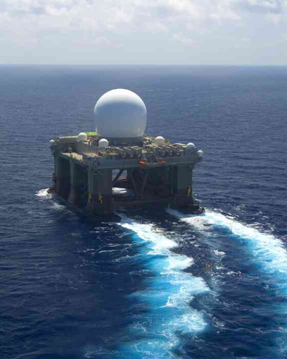
he Sea-Based X-Band Radar (SBX-1) is a powerful, floating radar system used by the United States Missile Defense Agency (MDA) as part of the Ballistic Missile Defense System (BMDS). It is one of the most advanced missile-tracking and discrimination radars in the world. The X-Band Radar uses high-frequency, providing extremely precise tracking of ballistic missiles, objects in space, and other threats.
Mounted on a modified semi-submersible oil-drilling platform, allowing global deployment and operation in various sea conditions.
It can differentiate between warheads, decoys, and debris in space, which is critical for missile defense.
It Works with the Ground-based Midcourse Defense (GMD) system to provide target tracking and discrimination for interceptors.
It Can be remotely controlled and operated from the United States, though it has a crew on board for maintenance and support.
The system was intrioduced in the cold war to track intercontinental ballistic missiles (ICBMs) and provides precise targeting data to missile interceptors, detect and monitor missile launches and space-based objects and were usually stationed in the Pacific, particularly near Hawaii or Alaska, and could be repositioned globally as needed. They had key advantages such as their high Sensitivity & Resolution to detect small objects at extremely long distances, mobility Unlike fixed radar installations and enhanced the ability of missile defense systems to hit incoming threats with high accuracy.
However the backside was their high Operational Costs both in Maintenance and deployment, limited Coverage and vulnerability to Rough Seas notably the effects of water spray in extreme weather.
Specifications
Dimensions: Approximately 390 feet (118.9 meters) long and 238 feet (72.5 meters) wide.
Height: Around 280 feet (85.3 meters) from keel to radar dome.
Radar Dome: Houses a massive phased-array radar covered by a 120-foot-wide dome.
Power Supply: Powered by six diesel generators providing nearly 75 megawatts of power.
Crew Size: Can accommodate around 80-85 personnel.
Speed: Can travel at around 9 knots (10 mph/17 km/h).
Floating Airport Concept
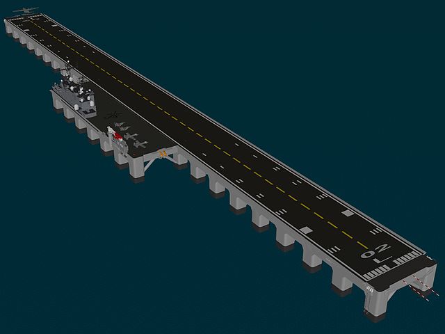
Floating airports are a large, mobile, or semi-permanent structure designed to operate in oceans, lakes, or other water bodies. This concept aims to address space limitations, congestion, and environmental concerns related to traditional land-based airports.
It could come in four Platform Types:
-Semi-submersible Platforms – Similar to oil rigs, these platforms remain stable in rough waters.
-Pontoon-based Structures – Large interconnected pontoons provide buoyancy and stability.
-Artificial Islands – Man-made floating landmasses that support full-scale airport operations.
-Ship-based Runways – Aircraft carriers or large ships modified for commercial aviation use.
They need a Wave Dampening Systems – Ensures runway stability by minimizing oceanic wave effects, possibly Magnetic Levitation (Maglev) Takeoff System to Reduce required runway length by using electromagnetic propulsion, such as the current USN EMALS, but for much larger jets.
The system supports Short Takeoff & Landing (STOL) Aircraft Compatibility and Enhances operational feasibility.
It cpild use Renewable Energy Integration – Solar panels, wind turbines, and wave energy for sustainable power.
On the civilian side, its Solves Land Shortage Issues, being ideal for densely populated coastal cities, reduces noise pollution when Located away from urban centers. For the Navy it offers flexibility & Mobility as it can be relocated based on demand.
However it also faces challenges & limitations such as High Construction & Maintenance Costs, Extreme Weather Vulnerability, had still a potential impact on marine ecosystems. Civilian examples currently are the “Mega-Float” Japanese prototype floating runway developed for research, Hong Kong’s Kai Tak Floating Airport Proposal (never built) and “Lilypad” Floating City-Airport (Concept). So far none were built but they are still considered by the USN for a potential war with China.
Mobile Offshore Base (MOB)

The concept bounced again more recently with the Mobile Offshore Base.
“Mobile offshore base (MOB), sometimes called a joint mobile offshore base (JMOB), is a concept for supporting military operations beyond the home shores, where conventional land bases are not available, by deploying on the high seas or in coastal waters, in-theater multipurpose floating base assembled from individual platforms. In essence, a MOB is a multipurpose modular self-propelled floating platform, or several interconnected platforms, that can perform multiple functions of a sea base including strike, deployment and logistics. An ocean-wise semi-submersible wave and wind resistant platform capable of moving at one-half the speed of conventional prepositioning monohull cargo ship has been researched and proposed, but never built. ”
Very Large Floating Structure concept
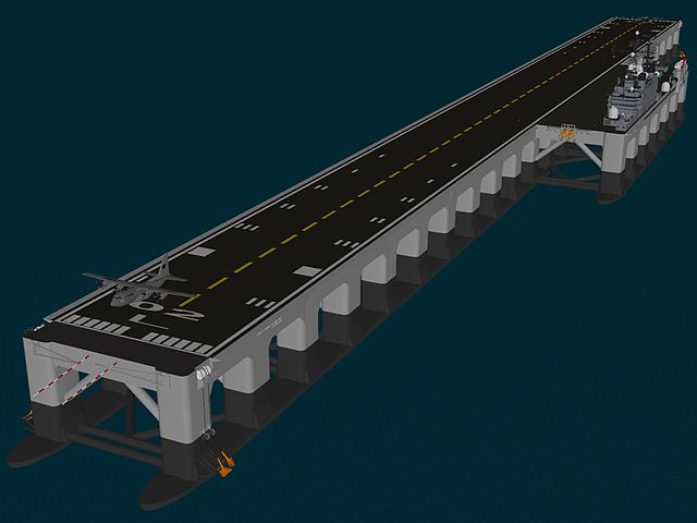
The “Very large floating structures” (VLFSs) or “very large floating platforms” (VLFPs) are conceptual artificial islands, a way to create floating airports, bridges, breakwaters, piers and docks as well as storage facilities for oil and natural gas and also installations for military purposes (extra industrial spaces, workshops, emergency bases). Several concepts are proposed every year of floating cities or huge living complexes and they presents many advantages. The USN studied such proposals and this made sense again in the new context of the the current situation in the Pacific. The USN will have the need fo extensive logistic hubs outside allied countrties, just as atolls were converted as advanced bacses in WW2 for the island hopping campaign.
Read More
Books
Links
src
https://en.wikipedia.org/wiki/History_of_the_petroleum_industry
https://aoghs.org/offshore-history/offshore-oil-history/
https://en.wikipedia.org/wiki/Coastal_defence_and_fortification#Sea_forts
https://en.wikipedia.org/wiki/Maunsell_Forts
https://en.wikipedia.org/wiki/Texas_Towers
https://en.wikipedia.org/wiki/Tanker_war

https://web.archive.org/web/20060616021956/http://www.undergroundkent.co.uk/maunsell_towers.htm
https://web.archive.org/web/20090123064542/http://whitstablescene.co.uk/forts.htm
http://www.users.zetnet.co.uk/mongsoft/forts.htm
https://en.wikipedia.org/wiki/Mobile_offshore_base
https://commons.wikimedia.org/wiki/Category:Oil_platforms
https://en.wikipedia.org/wiki/Sea-based_X-band_radar
https://en.wikipedia.org/wiki/Very_large_floating_structure
https://nationalinterest.org/blog/reboot/irans-1980-raid-iraqi-oil-platforms-was-nothing-short-audacious-182586/

 Latest Facebook Entry -
  X(Tweeter) Naval Encyclopedia's deck archive
 Instagram (@navalencyc)


 French Navy
 Royal Navy
 Russian Navy
 Armada Espanola
 Austrian Navy
 K.u.K. Kriegsmarine
 Dansk Marine
 Nautiko Hellenon
 Koninklije Marine 1870
 Marinha do Brasil
 Osmanlı Donanması
 Marina Do Peru
 Marinha do Portugal
 Regia Marina 1870
 Nihhon Kaigun 1870
 Preußische Marine 1870
 Russkiy Flot 1870
 Svenska marinen
 Søværnet
 Union Navy
 Confederate Navy
 Armada de Argentina
 Imperial Chinese Navy
 Marinha do Portugal
 Mexico
 Kaiserliche Marine
 1898 US Navy
 Sovietskiy Flot
 Royal Canadian Navy
 Royal Australian Navy
 RNZN Fleet
 Chinese Navy 1937
 Kriegsmarine
 Chilean Navy
 Danish Navy
 Finnish Navy
 Hellenic Navy
 Polish Navy
 Romanian Navy
 Turkish Navy
 Royal Yugoslav Navy
 Royal Thai Navy
 Minor Navies
 Albania
 Austria
 Belgium
 Columbia
 Costa Rica
 Cuba
Cuba Czechoslovakia
 Dominican Republic
 Haiti
Haiti Hungary
 Honduras
 Estonia
 Iceland
 Eire
Eire Equador
 Iran
Iran Iraq
Iraq Latvia
 Liberia
 Lithuania
 Mandchukuo
 Morocco
 Nicaragua
 Persia
 San Salvador
 Sarawak
 Uruguay
 Venezuela
 Zanzibar
 Warsaw Pact Navies
 Bulgaria
 Hungary

 Bundesmarine
 Dutch Navy
 Hellenic Navy
 Marina Militare
 Yugoslav Navy
 Chinese Navy
 Indian Navy
 Indonesian Navy
 JMSDF
JMSDF North Korean Navy
 Pakistani Navy
 Philippines Navy
 ROKN
ROKN Rep. of Singapore Navy
 Taiwanese Navy
 IDF Navy
 Saudi Navy
 Royal New Zealand Navy
 Egyptian Navy
 South African Navy


 Ukrainian Navy
 dbodesign